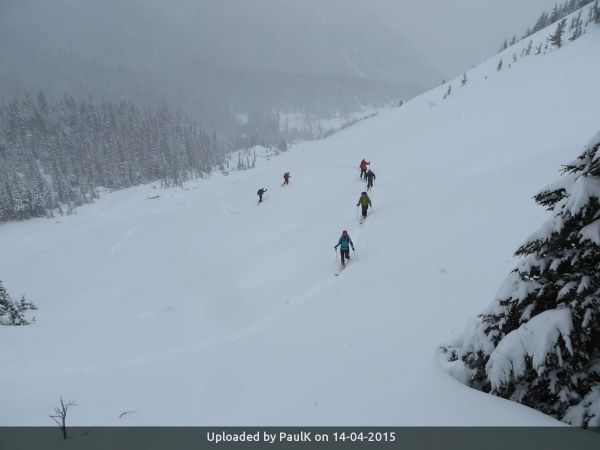
Participants: Paul Kubik, dog Linus, Nicolas Jimenez, dog Sacha, Filip Pulpan, Andrzej Jarzabek, Goran Babic, Christophe Lacour, Carl Douglas, Mandana Amiri, Dean Perez, and one more with Mandana
I had put the skis away with this crazy non-winter. Now it was back in mid April. It was time to check out the goods.
The weather had been unsettled and cold and was producing snow in copious amounts. The snow pillow data was showing a snow pack about 75% of average in the Tenquille Lake area compared with about 50% in the Squamish/Whistler area. A trip posted on CT the prior weekend showed a decent snowpack for skiing in the Ronayne area with good road access. There being no other ski trips for the weekend it was no surprise I had ten enthusiastic members join at the last minute.
I was trying to describe the route up on the trip page and came up with the "corkscrew route". To ski Mount Ronayne from the north there are two ways up: (1) Y-couloir, a direct line, (2) the so-called corkscrew route. Both routes start off North Tenas Branch off Birkenhead FSR. From the end of the road an improved snowmobile route cuts through a small band of trees to the base of Y-couloir. The corkscrew route continues up the main drainage on the west side of Ronayne, curves back south to cross a high col in the alpine, thence up the south bowl to the east ridge. The east ridge is followed to the summit. From the summit, it is possible to drop down into Y-couloir or retrace the corkscrew down.
An eleventh hour email from Dean the night before the trip - have you still room on the trip? How can I refuse? He's an unstoppable secret weapon when trail breaking.
From West Van we regrouped in Pemberton. Followed Hwy 99 east to Mount Currie, turned up the D'arcy road to Birkenhead FSR. Up the FSR for 9.8 K to the turnoff to North Tenas Branch. The branch road has minor cross-ditches and there was deepening snow on the road as we gained elevation. Nicolas' Forester started burning the clutch about 2 K so we carried their skis, while they walked from there. The other Forester with four people and the Xterra with three and a dog continued. We got about another 1.5 K where I decided to park before it got tricky. It was a good choice. It was only about 300 or 400 meters to the snowmobile track with limited opportunity to turn around.
The snowmobile community has been active over the last few years. North Tenas is a major snowmobile route to Ogre Lake. From the end of the road they have cut a narrow trail through the trees that goes directly to the base of Y-couloir. There is even a snowmobile bridge across the creek.
Snow travel was good. There was over two meters of snow depth at the creek and over boot top fresh snow on a firm base. No one was complaining about the conditions and everyone was delighted with the great access. There were also no snowmobiles and untracked snow everywhere. What's more, we were only about one hour from the upper parking and only had 800 meters of climbing left.
I had hyped the Y-couloir as a possible descent and even considered ascending it if the snow depth was insufficient for the corkscrew. Once we got to the base I could see the couloir had recently slid and was full of debris. The corkscrew was looking to be the only feasible way up and down if we wanted great skiing. It was an easy choice.
The sun was not threatening to come out at all and there was light snow. The snow conditions were dreamlike. We certainly had not experienced many days like this all winter down on the extreme South Coast. The snow was deep enough that the dogs were having a little bit of difficulty. I dropped to the rear after lunch to let the trail get packed down. There was a little bit of route finding required when we got up higher as the visibility was not ideal. However, memory and Google Earth impressions were still strong in my mind so it was easy to apply dead reckoning with only a minor and unnecessary assist from a GPS device at one point. We attained the south bowl easily enough and could then spy the east ridge off in the clouds. From there, the peak was practically in the bag.
The summit, duly attained, was the typical windswept crest and low visibility. Not much to see except the drop in to the couloir. There was some lee slope loading that was warned about in the avalanche forecast. All things considered, it was decided to ski the corkscrew back down rather than the couloir.
The skiing was great, especially nice after having been starved of powder in the backcountry for so long. It wasn't long before we were back at the lunch spot. My dog, now 10 years old, was having a bit of trouble keeping up in the deep snow for part of the descent. He maybe slowed us down by about an hour. Even so, we were back at the upper vehicles by 1600 hours. This was a short day - only six hours of skiing, a great ski route with an interesting name and an unusual destination without another party or snowmobile track in the entire valley.


| Trip Report Title | Mount Ronayne, Corkscrew Route |
- There are no comments yet


