August 9th - 15th, 2015
Participants: Paul Kubik, Doug Lonsbrough, Peter Malacarne
I would like to thank the Federation of Mountain Clubs for its financial support through the trails fund for the one week BCMC work party in August. I was joined by veteran trail builders Peter Malacarne and Doug Lonsbrough. I also want to thank Peter and Doug for their commitment. It is noteworthy when someone is willing to spend a week of their vacation time on a project that ultimately benefits many other individuals.
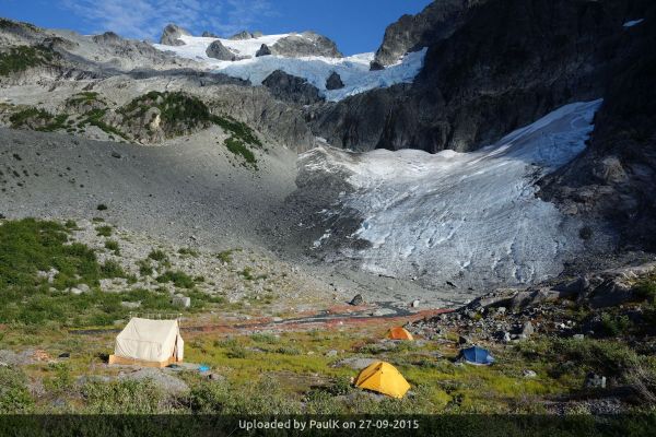
We set up at Moraine Camp below the north face of Ossa Mountain on the glacial outwash plain. We used the same site as last October’s camp, which was funded by the BCMC. The site for the large canvas 10 by 12 tent was reused. The outhouse facility we installed last year is still intact and usable.
Our primary objective was to clear a route for one kilometer through the west side of the moraine to Ossa Camp. This is the name applied to the informal, rocky camp site at a group of three small lakes on the way to the west ridge of Ossa Mountain. Rather than use the shortest distance path that had evolved over the years, we relocated a significant portion of the route to avoid a massive rock fall and swampy, wet ground. The new route is somewhat counterintuitive because it jogs 150 meters downstream to avoid the chief difficulties. The new route was cleared and rejoins the pre-existing route a short distance below the lakes where the upper camp lies.
Our secondary objective was to scout a route down into Sigurd headwaters. This objective was also met. The route roughly follows the 1230 meter contour along a heathered bench west of the moraine. The Ossa Camp trail branches off from the bench route about one third of the way along. The end of the bench is approximately one kilometer west of Moraine Camp. At its end, the route drops steeply down a vegetated gully for a vertical distance of 75 meters. The gully can mostly be hiked without the assistance of hands. At this time of year the gully was dry. We stopped flagging at the bottom of the gully. Having spent numerous bushwhacks examining possible routes from Moraine Camp into the headwaters, I firmly believe the 1230 meter contour and the 75 meter gully is the best option for accessing the headwaters of Sigurd Creek.
From the bottom of the 75 meter gully, generally open, rolling terrain leads to the upper lakes in Sigurd headwaters. The vegetation type in the headwaters is typically heather, thickets of mountain azalea and subalpine timber. Areas of sedge and grass occur in seasonally wet areas. The heathered bench this year had a particularly good harvest of large juicy and sweet blueberries. We saw a lot of bear sign on the bench. We did not spend much time examining the headwaters but did notice deer prints in muddy areas and the presence of a game trail in heavy timber. We did not observe any other ungulates or recognize any scat from other species.
From a wildlife and environmental impact point of view, what we call Moraine Camp is clearly the least harmful campsite option on the Ossa approach. We observed no large animal scat in the camp area. Wildlife would have difficulty traversing the enormous piles of boulders east and west of the camp. Below the camp is a huge slide alder swath. Above camp is steep rock and glacier. A glacial stream emanates from the toe of the lower icefield only 200 meters from camp. A prevailing wind off the glacier offers respite from annoying bugs which can be horrendous at times. The flat outwash plain provides for a lot of low impact tent sites and there is an established toilet facility.
Ossa Camp has the greater potential to impact wildlife because there is more vegetation and the presence of a large blueberry crop nearby. It links to Sigurd headwaters by the 1230 meter contour route I described or other bush routes so is easily accessible to wildlife. The lake water sources at the camp are questionable for potable water. There is no permanently flowing stream. There is no outhouse facility. There are no flat tent sites. The camp’s only advantage is that it is closer to the west ridge of Ossa. However, this advantage is lessened now that there is a decent footpath through the moraine. I estimate it is only twenty to thirty minutes from Moraine Camp to Ossa Camp with a light pack. A reasonable party could easily camp at Moraine Camp and still make short work of the west ridge climb. It would also save carrying a heavy overnight pack the final 300 meters up to the higher camp.
Planning for future work
The BCMC would like to continue to extend the trail into Sigurd headwaters and eventually Sigurd Lake. Two viable routes have been identified for reaching Sigurd Lake. I have requested approval of the work from BC Parks. It is my understanding it is awaiting a field visit by park staff to acquaint themselves with the proposed work and an examination of the impacts. The trail extension under proposal is envisioned in the master plan for the Esté-tiwilh/Sigurd Creek Conservancy. It will be a truly outstanding trail that will expand the appeal to the broader hiking community and continue to appeal to mountain climbers and backcountry skiers.
Photographers: Paul, Doug and Peter


| Trip Report Title | Sigurd Trail Work Week |
- There are no comments yet


